Log in
All resources
Create a design
348 Free Artworks of 1588 Maps
national library of poland
atlas ou representation du monde universel t. 2 (1633)
maps by hendrik hondius the younger
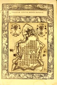
civitates orbis terrarum. urbium praecipuarum totius mundi. liber quartus
drawing
digital library of university of wroclaw
engraving
grabados
fondo antiguo
libros del siglo xvi
maps
city
maps
city
maps
city
maps
city
maps
city
maps
city
maps
city
maps
city
maps
city
maps
city
civitates orbis terrarum. urbium praecipuarum totius mundi. liber quartus
maps of hamburg by braun & hogenberg
maps
city
maps
city
maps
city
maps
city
cartography
maps
cartography
maps
maps
city
maps
city
maps of algiers by braun & hogenberg
bibliothèque nationale de france
maps
city
atlas ou representation du monde universel t. 2 (1633)
maps by hendrik hondius the younger
atlas ou representation du monde universel t. 2 (1633)
old maps of the republic of genoa
maps by nicolas sanson
jan van somer
gerardi mercatoris atlantis novi. pars tetria (1638)
17th-century maps of lombardy
prints by frans hogenberg in the rijksmuseum amsterdam
prints by jan luyken in the rijksmuseum amsterdam
maps of roanoke island
theodor de bry
prints by frans hogenberg in the rijksmuseum amsterdam
maps by jan luyken
civitates orbis terrarum. urbium praecipuarum totius mundi. liber quartus
maps of sloten by braun & hogenberg
civitates orbis terrarum. urbium praecipuarum totius mundi. liber quartus
maps of harlingen by braun & hogenberg
civitates orbis terrarum. urbium praecipuarum totius mundi. liber quartus
maps of malmö by braun & hogenberg
atlas ou representation du monde universel t. 2 (1633)
old maps of nuremberg
atlas ou representation du monde universel t. 2 (1633)
1630s maps of virginia
atlas ou representation du monde universel t. 2 (1633)
maps by hendrik hondius the younger
civitates orbis terrarum. urbium praecipuarum totius mundi. liber quartus
maps of malmö by braun & hogenberg
civitates orbis terrarum. urbium praecipuarum totius mundi. liber quartus
maps of lund by braun & hogenberg
atlas ou representation du monde universel t. 2 (1633)
17th-century maps of southeast asia
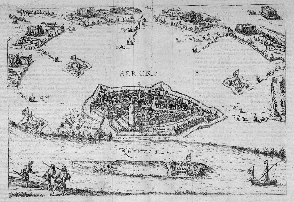
expeditionis hispanorum in angliam vera descriptio anno domini mdlxxxviii
maps in the library of congress
civitates orbis terrarum. urbium praecipuarum totius mundi. liber quartus
old maps of ancient rome (city)
expeditionis hispanorum in angliam vera descriptio anno domini mdlxxxviii
paper
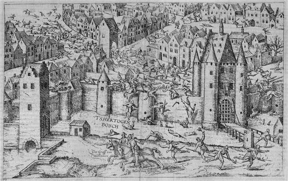
maps of 's-hertogenbosch by braun & hogenberg
atlas beudeker
atlas ou representation du monde universel t. 2 (1633)
maps by hendrik hondius the younger
atlas ou representation du monde universel t. 2 (1633)
1630s maps of lower saxony
civitates orbis terrarum. urbium praecipuarum totius mundi. liber quartus
maps of sneek by braun & hogenberg
civitates orbis terrarum. urbium praecipuarum totius mundi. liber quartus
maps of landskrona by braun & hogenberg
civitates orbis terrarum. urbium praecipuarum totius mundi. liber quartus
maps of ijlst by braun & hogenberg
lucas janszoon waghenaer
1588 maps of norway
atlas ou representation du monde universel t. 2 (1633)
17th-century maps of silesia
atlas ou representation du monde universel t. 2 (1633)
maps by hendrik hondius the younger
atlas ou representation du monde universel t. 2 (1633)
maps by jan janssonius
atlas ou representation du monde universel t. 2 (1633)
maps by hendrik hondius the younger
atlas ou representation du monde universel t. 2 (1633)
1633 maps of asia
atlas ou representation du monde universel t. 2 (1633)
maps by hendrik hondius the younger
atlas ou representation du monde universel t. 2 (1633)
maps by hendrik hondius the younger
atlas ou representation du monde universel t. 2 (1633)
maps of the duchy of mantua
atlas ou representation du monde universel t. 2 (1633)
1633 maps of africa
atlas ou representation du monde universel t. 2 (1633)
maps by hendrik hondius the younger
atlas ou representation du monde universel t. 2 (1633)
maps by hendrik hondius the younger
atlas ou representation du monde universel t. 2 (1633)
old maps of east frisia
atlas ou representation du monde universel t. 2 (1633)
maps by hendrik hondius the younger
atlas ou representation du monde universel t. 2 (1633)
maps of the duchy of milan
atlas ou representation du monde universel t. 2 (1633)
17th-century maps of paraguay
atlas ou representation du monde universel t. 2 (1633)
17th-century maps of bermuda
atlas ou representation du monde universel t. 2 (1633)
17th-century maps of peru
atlas ou representation du monde universel t. 2 (1633)
maps by hendrik hondius the younger
atlas ou representation du monde universel t. 2 (1633)
maps by hendrik hondius the younger
atlas ou representation du monde universel t. 2 (1633)
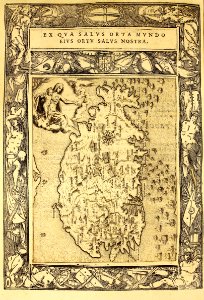
maps of sardinia by gerardus mercator
atlas ou representation du monde universel t. 2 (1633)
maps by hendrik hondius the younger
atlas ou representation du monde universel t. 2 (1633)
old maps of groningen (province)
atlas ou representation du monde universel t. 2 (1633)
1633 maps of africa
atlas ou representation du monde universel t. 2 (1633)
maps of the duchy of montferrat
atlas ou representation du monde universel t. 2 (1633)
maps by hendrik hondius the younger
atlas ou representation du monde universel t. 2 (1633)
17th-century maps of italy
atlas ou representation du monde universel t. 2 (1633)
maps by hendrik hondius the younger
atlas ou representation du monde universel t. 2 (1633)
maps by jan janssonius
atlas ou representation du monde universel t. 2 (1633)
maps of the county of mansfeld
atlas ou representation du monde universel t. 2 (1633)
old maps of nassau
atlas ou representation du monde universel t. 2 (1633)
maps of vicenza
atlas ou representation du monde universel t. 2 (1633)
17th-century maps of chile
a briefe and true report of the new found land of virginia
theodor de bry
expeditionis hispanorum in angliam vera descriptio anno domini mdlxxxviii
paper
expeditionis hispanorum in angliam vera descriptio anno domini mdlxxxviii
paper
expeditionis hispanorum in angliam vera descriptio anno domini mdlxxxviii
paper
expeditionis hispanorum in angliam vera descriptio anno domini mdlxxxviii
paper
atlas ou representation du monde universel t. 2 (1633)
17th-century maps of the strait of magellan
atlas ou representation du monde universel t. 2 (1633)
maps of bohemia by gerardus mercator
civitates orbis terrarum. urbium praecipuarum totius mundi. liber quartus
16th-century maps showing history
civitates orbis terrarum. urbium praecipuarum totius mundi. liber quartus
maps of krempe by braun & hogenberg
civitates orbis terrarum. urbium praecipuarum totius mundi. liber quartus
16th-century maps showing history
civitates orbis terrarum. urbium praecipuarum totius mundi. liber quartus
maps of oberwesel by braun & hogenberg
civitates orbis terrarum. urbium praecipuarum totius mundi. liber quartus
maps of marchena by braun & hogenberg
civitates orbis terrarum. urbium praecipuarum totius mundi. liber quartus
maps of mâcon by braun & hogenberg
civitates orbis terrarum. urbium praecipuarum totius mundi. liber quartus
1590s maps of denmark
civitates orbis terrarum. urbium praecipuarum totius mundi. liber quartus
maps of eisleben by braun & hogenberg
civitates orbis terrarum. urbium praecipuarum totius mundi. liber quartus
maps of sulmona by braun & hogenberg
civitates orbis terrarum. urbium praecipuarum totius mundi. liber quartus
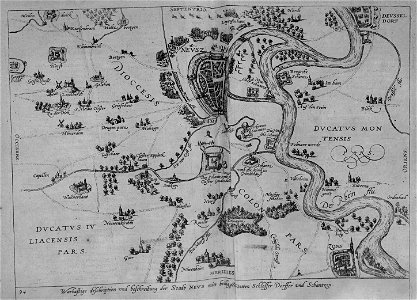
maps of dortmund by braun & hogenberg
civitates orbis terrarum. urbium praecipuarum totius mundi. liber quartus
maps of brixen by braun & hogenberg
maps of bergen op zoom by braun & hogenberg
atlas beudeker
civitates orbis terrarum. urbium praecipuarum totius mundi. liber quartus
maps of husum by braun & hogenberg
civitates orbis terrarum. urbium praecipuarum totius mundi. liber quartus
maps of itzehoe by braun & hogenberg
101 - 200 of 348
Next page
/ 4


![Algerii Sarace norum urbis forttis fimae, in Numidia Africae Provincia Structae iuxta Balearicos fluctus Maediterranei aequoris Hispaniam contra [...] / [Georg Braun]; [Franz Hogenberg], 1588](https://cdn.creazilla.com/illustrations/10000602342/algerii-sarace-norum-urbis-forttis-fimae-in-numidia-africae-provincia-structae-iuxta-balearicos-fluctus-maediterranei-aequoris-hispaniam-contra-georg-braun-franz-hogenberg-1588-md.jpg)
![Gerardi Mercatoris and I. Hondii Atlas or Representation of the Universal World, and of the Parts of It, Made in Tables and Very Ample Descriptions. [t. 2].](https://cdn.creazilla.com/illustrations/10001261552/gerardi-mercatoris-and-i-hondii-atlas-or-representation-of-the-universal-world-and-of-the-parts-of-it-made-in-tables-and-very-ample-descriptions-t-2-sm.webp)
![Gerardi Mercatoris and I. Hondii Atlas or Representation of the Universal World, and of the Parts of It, Made in Tables and Very Ample Descriptions. [t. 2].](https://cdn.creazilla.com/illustrations/10000735247/gerardi-mercatoris-and-i-hondii-atlas-or-representation-of-the-universal-world-and-of-the-parts-of-it-made-in-tables-and-very-ample-descriptions-t-2-sm.webp)


![Gerardi Mercatoris and I. Hondii Atlas or Representation of the Universal World, and of the Parts of It, Made in Tables and Very Ample Descriptions. [t. 2].](https://cdn.creazilla.com/illustrations/10001133003/gerardi-mercatoris-and-i-hondii-atlas-or-representation-of-the-universal-world-and-of-the-parts-of-it-made-in-tables-and-very-ample-descriptions-t-2-sm.webp)
![Gerardi Mercatoris and I. Hondii Atlas or Representation of the Universal World, and of the Parts of It, Made in Tables and Very Ample Descriptions. [t. 2].](https://cdn.creazilla.com/illustrations/10001569396/gerardi-mercatoris-and-i-hondii-atlas-or-representation-of-the-universal-world-and-of-the-parts-of-it-made-in-tables-and-very-ample-descriptions-t-2-sm.webp)
![Gerardi Mercatoris and I. Hondii Atlas or Representation of the Universal World, and of the Parts of It, Made in Tables and Very Ample Descriptions. [t. 2].](https://cdn.creazilla.com/illustrations/10000421870/gerardi-mercatoris-and-i-hondii-atlas-or-representation-of-the-universal-world-and-of-the-parts-of-it-made-in-tables-and-very-ample-descriptions-t-2-md.jpg)


![Gerardi Mercatoris and I. Hondii Atlas or Representation of the Universal World, and of the Parts of It, Made in Tables and Very Ample Descriptions. [t. 2].](https://cdn.creazilla.com/illustrations/10000597422/gerardi-mercatoris-and-i-hondii-atlas-or-representation-of-the-universal-world-and-of-the-parts-of-it-made-in-tables-and-very-ample-descriptions-t-2-md.jpg)


![Gerardi Mercatoris and I. Hondii Atlas or Representation of the Universal World, and of the Parts of It, Made in Tables and Very Ample Descriptions. [t. 2].](https://cdn.creazilla.com/illustrations/10001326081/gerardi-mercatoris-and-i-hondii-atlas-or-representation-of-the-universal-world-and-of-the-parts-of-it-made-in-tables-and-very-ample-descriptions-t-2-md.jpg)
![Gerardi Mercatoris and I. Hondii Atlas or Representation of the Universal World, and of the Parts of It, Made in Tables and Very Ample Descriptions. [t. 2].](https://cdn.creazilla.com/illustrations/10001514456/gerardi-mercatoris-and-i-hondii-atlas-or-representation-of-the-universal-world-and-of-the-parts-of-it-made-in-tables-and-very-ample-descriptions-t-2-md.jpg)


![Gerardi Mercatoris and I. Hondii Atlas or Representation of the Universal World, and of the Parts of It, Made in Tables and Very Ample Descriptions. [t. 2].](https://cdn.creazilla.com/illustrations/10000404015/gerardi-mercatoris-and-i-hondii-atlas-or-representation-of-the-universal-world-and-of-the-parts-of-it-made-in-tables-and-very-ample-descriptions-t-2-sm.webp)
![Gerardi Mercatoris and I. Hondii Atlas or Representation of the Universal World, and of the Parts of It, Made in Tables and Very Ample Descriptions. [t. 2].](https://cdn.creazilla.com/illustrations/10000416251/gerardi-mercatoris-and-i-hondii-atlas-or-representation-of-the-universal-world-and-of-the-parts-of-it-made-in-tables-and-very-ample-descriptions-t-2-sm.webp)
![Gerardi Mercatoris and I. Hondii Atlas or Representation of the Universal World, and of the Parts of It, Made in Tables and Very Ample Descriptions. [t. 2].](https://cdn.creazilla.com/illustrations/10000306998/gerardi-mercatoris-and-i-hondii-atlas-or-representation-of-the-universal-world-and-of-the-parts-of-it-made-in-tables-and-very-ample-descriptions-t-2-sm.webp)
![Gerardi Mercatoris and I. Hondii Atlas or Representation of the Universal World, and of the Parts of It, Made in Tables and Very Ample Descriptions. [t. 2].](https://cdn.creazilla.com/illustrations/10000334523/gerardi-mercatoris-and-i-hondii-atlas-or-representation-of-the-universal-world-and-of-the-parts-of-it-made-in-tables-and-very-ample-descriptions-t-2-sm.webp)
![Gerardi Mercatoris and I. Hondii Atlas or Representation of the Universal World, and of the Parts of It, Made in Tables and Very Ample Descriptions. [t. 2].](https://cdn.creazilla.com/illustrations/10000298832/gerardi-mercatoris-and-i-hondii-atlas-or-representation-of-the-universal-world-and-of-the-parts-of-it-made-in-tables-and-very-ample-descriptions-t-2-sm.webp)
![Gerardi Mercatoris and I. Hondii Atlas or Representation of the Universal World, and of the Parts of It, Made in Tables and Very Ample Descriptions. [t. 2].](https://cdn.creazilla.com/illustrations/10000550104/gerardi-mercatoris-and-i-hondii-atlas-or-representation-of-the-universal-world-and-of-the-parts-of-it-made-in-tables-and-very-ample-descriptions-t-2-md.jpg)
![Gerardi Mercatoris and I. Hondii Atlas or Representation of the Universal World, and of the Parts of It, Made in Tables and Very Ample Descriptions. [t. 2].](https://cdn.creazilla.com/illustrations/10000199512/gerardi-mercatoris-and-i-hondii-atlas-or-representation-of-the-universal-world-and-of-the-parts-of-it-made-in-tables-and-very-ample-descriptions-t-2-sm.webp)
![Gerardi Mercatoris and I. Hondii Atlas or Representation of the Universal World, and of the Parts of It, Made in Tables and Very Ample Descriptions. [t. 2].](https://cdn.creazilla.com/illustrations/10001224485/gerardi-mercatoris-and-i-hondii-atlas-or-representation-of-the-universal-world-and-of-the-parts-of-it-made-in-tables-and-very-ample-descriptions-t-2-sm.webp)
![Gerardi Mercatoris and I. Hondii Atlas or Representation of the Universal World, and of the Parts of It, Made in Tables and Very Ample Descriptions. [t. 2].](https://cdn.creazilla.com/illustrations/10001256230/gerardi-mercatoris-and-i-hondii-atlas-or-representation-of-the-universal-world-and-of-the-parts-of-it-made-in-tables-and-very-ample-descriptions-t-2-md.jpg)
![Gerardi Mercatoris and I. Hondii Atlas or Representation of the Universal World, and of the Parts of It, Made in Tables and Very Ample Descriptions. [t. 2].](https://cdn.creazilla.com/illustrations/10001074814/gerardi-mercatoris-and-i-hondii-atlas-or-representation-of-the-universal-world-and-of-the-parts-of-it-made-in-tables-and-very-ample-descriptions-t-2-sm.webp)
![Gerardi Mercatoris and I. Hondii Atlas or Representation of the Universal World, and of the Parts of It, Made in Tables and Very Ample Descriptions. [t. 2].](https://cdn.creazilla.com/illustrations/10001294385/gerardi-mercatoris-and-i-hondii-atlas-or-representation-of-the-universal-world-and-of-the-parts-of-it-made-in-tables-and-very-ample-descriptions-t-2-sm.webp)
![Gerardi Mercatoris and I. Hondii Atlas or Representation of the Universal World, and of the Parts of It, Made in Tables and Very Ample Descriptions. [t. 2].](https://cdn.creazilla.com/illustrations/10001383734/gerardi-mercatoris-and-i-hondii-atlas-or-representation-of-the-universal-world-and-of-the-parts-of-it-made-in-tables-and-very-ample-descriptions-t-2-md.jpg)
![Gerardi Mercatoris and I. Hondii Atlas or Representation of the Universal World, and of the Parts of It, Made in Tables and Very Ample Descriptions. [t. 2].](https://cdn.creazilla.com/illustrations/10001497746/gerardi-mercatoris-and-i-hondii-atlas-or-representation-of-the-universal-world-and-of-the-parts-of-it-made-in-tables-and-very-ample-descriptions-t-2-sm.webp)
![Gerardi Mercatoris and I. Hondii Atlas or Representation of the Universal World, and of the Parts of It, Made in Tables and Very Ample Descriptions. [t. 2].](https://cdn.creazilla.com/illustrations/10001480761/gerardi-mercatoris-and-i-hondii-atlas-or-representation-of-the-universal-world-and-of-the-parts-of-it-made-in-tables-and-very-ample-descriptions-t-2-sm.webp)
![Gerardi Mercatoris and I. Hondii Atlas or Representation of the Universal World, and of the Parts of It, Made in Tables and Very Ample Descriptions. [t. 2].](https://cdn.creazilla.com/illustrations/10000511702/gerardi-mercatoris-and-i-hondii-atlas-or-representation-of-the-universal-world-and-of-the-parts-of-it-made-in-tables-and-very-ample-descriptions-t-2-sm.webp)
![Gerardi Mercatoris and I. Hondii Atlas or Representation of the Universal World, and of the Parts of It, Made in Tables and Very Ample Descriptions. [t. 2].](https://cdn.creazilla.com/illustrations/10000384995/gerardi-mercatoris-and-i-hondii-atlas-or-representation-of-the-universal-world-and-of-the-parts-of-it-made-in-tables-and-very-ample-descriptions-t-2-sm.webp)
![Gerardi Mercatoris and I. Hondii Atlas or Representation of the Universal World, and of the Parts of It, Made in Tables and Very Ample Descriptions. [t. 2].](https://cdn.creazilla.com/illustrations/10000378633/gerardi-mercatoris-and-i-hondii-atlas-or-representation-of-the-universal-world-and-of-the-parts-of-it-made-in-tables-and-very-ample-descriptions-t-2-sm.webp)
![Gerardi Mercatoris and I. Hondii Atlas or Representation of the Universal World, and of the Parts of It, Made in Tables and Very Ample Descriptions. [t. 2].](https://cdn.creazilla.com/illustrations/10000841463/gerardi-mercatoris-and-i-hondii-atlas-or-representation-of-the-universal-world-and-of-the-parts-of-it-made-in-tables-and-very-ample-descriptions-t-2-md.jpg)
![Gerardi Mercatoris and I. Hondii Atlas or Representation of the Universal World, and of the Parts of It, Made in Tables and Very Ample Descriptions. [t. 2].](https://cdn.creazilla.com/illustrations/10000853185/gerardi-mercatoris-and-i-hondii-atlas-or-representation-of-the-universal-world-and-of-the-parts-of-it-made-in-tables-and-very-ample-descriptions-t-2-sm.webp)
![Gerardi Mercatoris and I. Hondii Atlas or Representation of the Universal World, and of the Parts of It, Made in Tables and Very Ample Descriptions. [t. 2].](https://cdn.creazilla.com/illustrations/10000945988/gerardi-mercatoris-and-i-hondii-atlas-or-representation-of-the-universal-world-and-of-the-parts-of-it-made-in-tables-and-very-ample-descriptions-t-2-md.jpg)
![Gerardi Mercatoris and I. Hondii Atlas or Representation of the Universal World, and of the Parts of It, Made in Tables and Very Ample Descriptions. [t. 2].](https://cdn.creazilla.com/illustrations/10001371723/gerardi-mercatoris-and-i-hondii-atlas-or-representation-of-the-universal-world-and-of-the-parts-of-it-made-in-tables-and-very-ample-descriptions-t-2-sm.webp)
![Gerardi Mercatoris and I. Hondii Atlas or Representation of the Universal World, and of the Parts of It, Made in Tables and Very Ample Descriptions. [t. 2].](https://cdn.creazilla.com/illustrations/10000588105/gerardi-mercatoris-and-i-hondii-atlas-or-representation-of-the-universal-world-and-of-the-parts-of-it-made-in-tables-and-very-ample-descriptions-t-2-md.jpg)
![Gerardi Mercatoris and I. Hondii Atlas or Representation of the Universal World, and of the Parts of It, Made in Tables and Very Ample Descriptions. [t. 2].](https://cdn.creazilla.com/illustrations/10000506992/gerardi-mercatoris-and-i-hondii-atlas-or-representation-of-the-universal-world-and-of-the-parts-of-it-made-in-tables-and-very-ample-descriptions-t-2-sm.webp)
![Gerardi Mercatoris and I. Hondii Atlas or Representation of the Universal World, and of the Parts of It, Made in Tables and Very Ample Descriptions. [t. 2].](https://cdn.creazilla.com/illustrations/10001186009/gerardi-mercatoris-and-i-hondii-atlas-or-representation-of-the-universal-world-and-of-the-parts-of-it-made-in-tables-and-very-ample-descriptions-t-2-sm.webp)
![Gerardi Mercatoris and I. Hondii Atlas or Representation of the Universal World, and of the Parts of It, Made in Tables and Very Ample Descriptions. [t. 2].](https://cdn.creazilla.com/illustrations/10000776653/gerardi-mercatoris-and-i-hondii-atlas-or-representation-of-the-universal-world-and-of-the-parts-of-it-made-in-tables-and-very-ample-descriptions-t-2-md.jpg)
![Gerardi Mercatoris and I. Hondii Atlas or Representation of the Universal World, and of the Parts of It, Made in Tables and Very Ample Descriptions. [t. 2].](https://cdn.creazilla.com/illustrations/10000831433/gerardi-mercatoris-and-i-hondii-atlas-or-representation-of-the-universal-world-and-of-the-parts-of-it-made-in-tables-and-very-ample-descriptions-t-2-sm.webp)
![Gerardi Mercatoris and I. Hondii Atlas or Representation of the Universal World, and of the Parts of It, Made in Tables and Very Ample Descriptions. [t. 2].](https://cdn.creazilla.com/illustrations/10001307107/gerardi-mercatoris-and-i-hondii-atlas-or-representation-of-the-universal-world-and-of-the-parts-of-it-made-in-tables-and-very-ample-descriptions-t-2-sm.webp)
![Gerardi Mercatoris and I. Hondii Atlas or Representation of the Universal World, and of the Parts of It, Made in Tables and Very Ample Descriptions. [t. 2].](https://cdn.creazilla.com/illustrations/10001295296/gerardi-mercatoris-and-i-hondii-atlas-or-representation-of-the-universal-world-and-of-the-parts-of-it-made-in-tables-and-very-ample-descriptions-t-2-sm.webp)
![Gerardi Mercatoris and I. Hondii Atlas or Representation of the Universal World, and of the Parts of It, Made in Tables and Very Ample Descriptions. [t. 2].](https://cdn.creazilla.com/illustrations/10001013822/gerardi-mercatoris-and-i-hondii-atlas-or-representation-of-the-universal-world-and-of-the-parts-of-it-made-in-tables-and-very-ample-descriptions-t-2-sm.webp)
![Gerardi Mercatoris and I. Hondii Atlas or Representation of the Universal World, and of the Parts of It, Made in Tables and Very Ample Descriptions. [t. 2].](https://cdn.creazilla.com/illustrations/10001411837/gerardi-mercatoris-and-i-hondii-atlas-or-representation-of-the-universal-world-and-of-the-parts-of-it-made-in-tables-and-very-ample-descriptions-t-2-sm.webp)
![Gerardi Mercatoris and I. Hondii Atlas or Representation of the Universal World, and of the Parts of It, Made in Tables and Very Ample Descriptions. [t. 2].](https://cdn.creazilla.com/illustrations/10000739776/gerardi-mercatoris-and-i-hondii-atlas-or-representation-of-the-universal-world-and-of-the-parts-of-it-made-in-tables-and-very-ample-descriptions-t-2-md.jpg)
![Gerardi Mercatoris and I. Hondii Atlas or Representation of the Universal World, and of the Parts of It, Made in Tables and Very Ample Descriptions. [t. 2].](https://cdn.creazilla.com/illustrations/10001531963/gerardi-mercatoris-and-i-hondii-atlas-or-representation-of-the-universal-world-and-of-the-parts-of-it-made-in-tables-and-very-ample-descriptions-t-2-sm.webp)


![Gerardi Mercatoris and I. Hondii Atlas or Representation of the Universal World, and of the Parts of It, Made in Tables and Very Ample Descriptions. [t. 2].](https://cdn.creazilla.com/illustrations/10001243780/gerardi-mercatoris-and-i-hondii-atlas-or-representation-of-the-universal-world-and-of-the-parts-of-it-made-in-tables-and-very-ample-descriptions-t-2-sm.webp)
![Gerardi Mercatoris and I. Hondii Atlas or Representation of the Universal World, and of the Parts of It, Made in Tables and Very Ample Descriptions. [t. 2].](https://cdn.creazilla.com/illustrations/10000238363/gerardi-mercatoris-and-i-hondii-atlas-or-representation-of-the-universal-world-and-of-the-parts-of-it-made-in-tables-and-very-ample-descriptions-t-2-sm.webp)


